Ladakh
Home / Guides / Ladakh
North India · Union Territory

Ladakh

High passes and moonscapes

Photo: KennyOMG, CC BY-SA 4.0
Capital

Leh

Best time to visit

May to September

Getting there

Fly into Leh year-round, or drive from Manali or Srinagar in summer. Inner Line Permits are needed for some areas.

Ideal trip

10 to 14 days to cover the highlights

About Ladakh

Ladakh is a high-altitude desert of monasteries, turquoise lakes and some of the highest motorable roads. Rest for at least two days in Leh to acclimatise.

Plan a trip to LadakhMark it on my map

Popular cities in Ladakh

Been to any? Mark them on your India travel map.

Diskit (Nubra)DrassHanleKargilKhalatseLamayuruLehNyomaPadumTurtuk

Top places in Ladakh

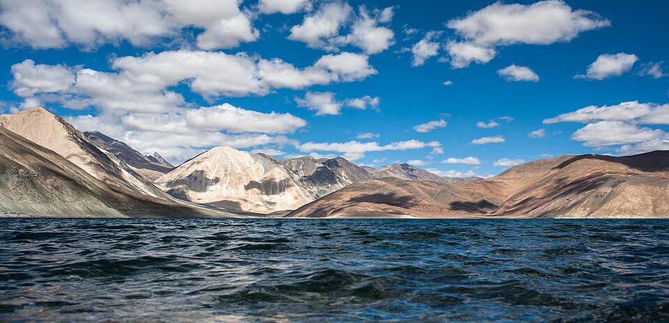
Pangong TsoPhoto: KennyOMG, CC BY-SA 4.0

Pangong Tso

A long, colour-changing lake at about 4,225 m.

Best time: May to SeptemberBase: Leh2 daysNatureMountains
Directions
From Wikipedia

Pangong Tso or Pangong Lake is an endorheic lake spanning eastern Ladakh in India and Ngari Prefecture in Tibet. Situated at an elevation of 14,200 ft, it occupies an area of approximately 604 km2. It stretches for 134 km and is 5 km wide at its broadest point. It is located in a landlocked basin and is separated from the Indus River basin by an elevated ridge. The water is saline, and the lake freezes during winter.

Read more on Wikipedia ↗

Video by Manaan Kar Ray on YouTube

Nubra ValleyPhoto: Addy6697, CC BY-SA 4.0

Nubra Valley

Sand dunes, Bactrian camels and Diskit Monastery, reached over Khardung La.

Best time: May to SeptemberBase: Diskit2 daysNatureAdventure
Directions
From Wikipedia

Nubra, also called Dumra, is a historical region of Ladakh, India that is currently administered as a subdivision and a tehsil in the Nubra district. Its inhabited areas form a tri-armed valley cut by the Nubra and Shyok rivers. Its Tibetan name Dumra means "valley of flowers". Demands have long been raised for the creation of a Nubra district. On 27 April 2026, the Lieutenant-Governor of Ladakh approved the formation of a new district.

Read more on Wikipedia ↗

Video by GovZ Travels on YouTube

Leh Palace and townPhoto: KennyOMG, CC BY-SA 4.0

Leh Palace and town

A nine-storey 17th-century palace above Leh's old town and cafes.

Best time: May to SeptemberBase: Leh2 daysHeritageCity
Directions
From Wikipedia

Leh Palace, also known as Lachen Palkar Palace, is a former royal palace overlooking the city of Leh in Ladakh, India. It was constructed circa 1600 AD by Sengge Namgyal. The palace was abandoned when Dogra forces took control of Ladakh in the mid-19th century and forced the royal family to move to Stok Palace.

Read more on Wikipedia ↗

Video by Shiva Tells on YouTube

Hemis MonasteryPhoto: Bernard Gagnon, CC BY-SA 4.0

Hemis Monastery

The largest monastery in Ladakh and home to the summer Hemis festival.

Best time: May to SeptemberBase: Leh1 daySpiritualHeritage
Directions
From Wikipedia

Hemis Monastery is a Himalayan Buddhist monastery of the Drukpa Lineage, in Hemis on the bank of the Indus River, Ladakh, India. Situated 45 km from Leh, it was re-established in 1672 by the Ladakhi king Sengge Namgyal. The annual Hemis festival honouring Padmasambhava is held there in early June. Hemis village is located 40 km southeast of Leh on Leh-Manali Highway and under-construction Bhanupli–Leh line.

Read more on Wikipedia ↗

Video by Vargis Khan on YouTube

LamayuruPhoto: Vyacheslav Argenberg, CC BY 4.0

Lamayuru

One of Ladakh's oldest monasteries above eroded moonland formations.

Best time: May to SeptemberBase: Lamayuru1 daySpiritualMountains
Directions
From Wikipedia

Lamayuru or Yuru Monastery is a Tibetan Buddhist monastery in Lamayouro village of Leh district in Ladakh in India. These natural caves were inhabited by monks for meditation, forming a cave monastery, particularly the famous "meditation cave of Naropa" preserved within the monastery's central hall. It is situated on the NH1 Srinagar-Leh Highway 15 kilometres east of the Fotu La at a height of 3,510 metres and 19 km southwest of Khalsi. The area is popular among tourists for its moonscape-like rocky appearance.

Read more on Wikipedia ↗
Khardung LaPhoto: Vyacheslav Argenberg, CC BY 4.0

Khardung La

A high motorable pass at 5,359 m on the road from Leh to Nubra.

Best time: June to SeptemberBase: Leh1 dayAdventureMountains
Directions
From Wikipedia

Khardung La or Khardung Pass, 40 km north of Leh city, is a mountain pass in the Leh district of the union territory of Ladakh in India. The pass is on the Ladakh Range and connects the Indus river valley and the Shyok river valley. A strategically important motorable road from Leh in the south, built in 1976 by the Border Roads Organisation, connects to the Nubra Valley in north and also to the Siachen Glacier. The road is one of the world's highest motorable roads.

Read more on Wikipedia ↗
ZanskarPhoto: Corto Maltese 1999, CC BY 2.0

Zanskar

A remote valley of Padum, Phugtal monastery and the frozen Chadar river trek in winter.

Best time: June to SeptemberBase: Padum4 daysAdventureMountains
Directions
From Wikipedia

Zanskar, Zahar or Zangskar, is a district and region in the Union Territory of Ladakh in India. Zanskar, together with the rest of Ladakh, was briefly a part of the kingdom of Western Tibet called Ngari Khorsum. Zanskar lies 250 km south of Kargil City on NH301. In August 2024, the Ministry of Home Affairs announced that Zanskar will become a district in Ladakh by 2028. On 27 April 2026, Zanskar became a new district, with headquarters at Padum.

Read more on Wikipedia ↗
Kargil and DrassPhoto: Narender9, CC BY-SA 3.0

Kargil and Drass

The Kargil War Memorial at Drass, one of the coldest inhabited places on earth.

Best time: May to OctoberBase: Kargil1 dayHeritageMountains
Directions
From Wikipedia

Dras, also known locally as Himababs, Hembabs, Ranbirpura or Humas, is a town, hill station and headquarters of eponymous tehsil and community development block in Drass district of the union territory of Ladakh in India. It is on the NH 1 between Zoji La pass and Kargil town. A tourist hub for its high-altitude trekking routes and tourist sites, it is often called "The Gateway to Ladakh". The government's official spelling of the town's name is "Drass".

Read more on Wikipedia ↗
Tso MoririHidden gemPhoto: Tanay Kibe, CC BY-SA 2.0

Tso Moriri

A quieter high-altitude lake in Changthang, home to nomadic herders.

Best time: June to SeptemberBase: Korzok2 daysNatureMountains
Directions
From Wikipedia

Tso Moriri or Lake Moriri, 4,522 m, is a high-altitude lake and a Ramsar wetland site in the remote Changthang Plateau in the Changthang district of the union territory of Ladakh in India. As the largest high-altitude lake entirely within India and Ladakh's Trans-Himalayan region, it spans 26 km north-south and 4-8 km wide. The lake is fed by three primary glacial streams - Karzok Phu, Gyama Phu, and Phirse Phu - which form extensive marshes at their deltas.

Read more on Wikipedia ↗

Video by Abhijit Ahaskar on YouTube

TurtukHidden gemPhoto: Rajnish71, CC BY-SA 4.0

Turtuk

A Balti village of apricot orchards near the Line of Control, opened to tourists in 2010.

Best time: May to SeptemberBase: Turtuk1 dayCultureNature
Directions
From Wikipedia

Turtuk is a town, the headquarters of the eponymous tehsil and community development block in the Nubra district of Indian union territory of Ladakh. Situated on the banks of the Shyok River, sandwiched between the Karakorum Range and the Himalayas, and one of the northernmost habitations of India, close to the Line of Control between India and Pakistan.

Read more on Wikipedia ↗

Food to try

Thukpa, skyu, momos, butter tea, apricot jam and kahwa

Where to stay

Leh guesthouses and hotels, camps at Nubra, Pangong and Tso Moriri

Getting around

Fly into Leh, or drive from Manali or Srinagar in summer; hired taxis for sightseeing

Good to know

Rest for 48 hours in Leh to acclimatise. Inner Line Permits are needed for Nubra, Pangong and Tso Moriri.

History of Ladakh

Ladakh is a high altitude desert lying between the Himalaya and the Karakoram, and people have lived and travelled here since prehistoric times. Rock carvings found across the region, showing ibex, hunters and symbols, record the presence of early communities over thousands of years. Early inhabitants are thought to have included Dard and Mon peoples, and later many settlers came from Tibet. Buddhism reached Ladakh early, spreading from Kashmir and later from Tibet, and ancient rock carvings such as the large standing Maitreya Buddha at Mulbekh show its long presence.

Around the 10th century, after the break up of the Tibetan empire, a prince of the old Tibetan royal line founded a kingdom in western Tibet, and Ladakh emerged as a kingdom known as Maryul under his descendants. Around the turn of the 11th century the great translator Rinchen Zangpo helped spread Buddhist learning in the western Himalaya, and many early temples are associated with him. The Alchi temple complex, with exquisite murals and wood carvings from around the 11th to 12th centuries, is one of the treasures of Ladakh. Lamayuru, among the oldest monasteries in the region, perches dramatically above a moonlike landscape.

In the 16th century the Namgyal dynasty came to power and ruled Ladakh for around three centuries. Its most celebrated king, Sengge Namgyal, reigned in the early 17th century and built the nine storey Leh Palace that still towers over the town. He was also a patron of Hemis Monastery, now famous for its summer festival. Other great monasteries such as Thiksey, Spituk, Diskit and Likir grew in importance. In the late 17th century Ladakh fought a war with Tibet, and with Mughal help the conflict ended with the Treaty of Tingmosgang in 1684, which set the terms of relations with Tibet.

For centuries Leh was a key trading hub on caravan routes linking Kashmir, Tibet, Central Asia and Punjab. Traders carried pashmina wool, salt, tea, silk and other goods across high passes, and the old town of Leh, with its narrow lanes and mud brick houses, grew around this commerce. In the 1830s the Dogra general Zorawar Singh, serving Gulab Singh of Jammu, conquered Ladakh. After 1846 it became part of the princely state of Jammu and Kashmir, and the Namgyal royal family moved to Stok Palace, which today houses a museum of royal heirlooms.

After independence in 1947, Ladakh remained a region of the state of Jammu and Kashmir. It was organised into the districts of Leh and Kargil, with Kargil district created in 1979. Autonomous Hill Development Councils were later set up for Leh in 1995 and Kargil in 2003 to give local communities a greater role in development. The region opened to foreign tourists in the 1970s, and travel has since become an important part of the local economy.

Under the Jammu and Kashmir Reorganisation Act of 2019, Ladakh was separated from Jammu and Kashmir and became a union territory without a legislature on 31 October 2019. Leh serves as the main administrative centre, with Kargil as the other key hub. Today travellers come for Ladakh's monasteries, palaces, high passes and lakes, and for a living Buddhist and Islamic culture shaped by centuries of trade and faith.

Ladakh: quick answers

What is the best time to visit Ladakh?

May to September

How do I reach Ladakh?

Fly into Leh year-round, or drive from Manali or Srinagar in summer. Inner Line Permits are needed for some areas.

How many days do I need for Ladakh?

Plan 10 to 14 days to see the highlights, such as Pangong Tso, Nubra Valley, Leh Palace and town.

What food should I try in Ladakh?

Thukpa, skyu, momos, butter tea, apricot jam and kahwa

Where should I stay in Ladakh?

Leh guesthouses and hotels, camps at Nubra, Pangong and Tso Moriri

Neighbouring states

Timings, fees, permits and road conditions change. Please check official sources before you travel.