Jharkhand
Home / Guides / Jharkhand
East India · State

Jharkhand

Plateau waterfalls and sal forests

Photo: Kingshuk Mondal, CC BY 4.0
Capital

Ranchi

Best time to visit

October to March (waterfalls peak July to October)

Getting there

Fly or take a train to Ranchi. Most sights are a 1 to 4 hour drive away.

Ideal trip

4 to 6 days to cover the highlights

About Jharkhand

Jharkhand sits on the Chota Nagpur plateau. Its waterfalls, forests and tribal heritage remain off the main tourist trail.

Plan a trip to JharkhandMark it on my map

Popular cities in Jharkhand

Been to any? Mark them on your India travel map.

BokaroChaibasaChatraDaltonganj (Medininagar)DeogharDhanbadDumkaGarhwaGiridihGoddaGumlaHazaribaghJamshedpur (Tatanagar)JamtaraKhuntiKodermaLateharLohardagaMcCluskieganjNetarhatPakurRamgarhRanchiSahebganjSeraikelaSimdega

Top places in Jharkhand

Hundru FallsPhoto: Kingshuk Mondal, CC BY 4.0

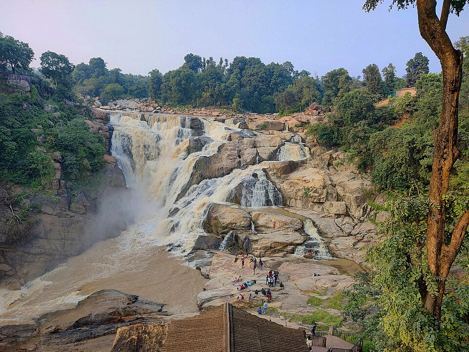
Hundru Falls

The Subarnarekha river drops about 98 m here, a short drive from Ranchi.

Best time: July to FebruaryBase: Ranchi1 dayNature
Directions
From Wikipedia

Hundru Falls is a waterfall located in Ranchi District in the Indian state of Jharkhand. It is the 34th highest waterfall in India, and one of the most famous tourist places in the region.

Read more on Wikipedia ↗

Video by Somjit Bhattacharyya on YouTube

Baidyanath Dham, DeogharPhoto: Pinakpani, CC BY 4.0

Baidyanath Dham, Deoghar

One of the twelve Jyotirlingas, crowded during the Shravani Mela.

Best time: October to MarchBase: Deoghar1 daySpiritual
Directions
From Wikipedia

Baidyanath Temple is a Hindu temple dedicated to Shiva. It is located in Deoghar, in the Santhal Parganas division of the Indian state of Jharkhand. The temple complex comprises the central shrine of Baba Baidyanath along with 21 additional temples. It is significant to the Hindu sects of Shaivism as this temple is referred to as one of the twelve Jyotirlingas.

Read more on Wikipedia ↗

Video by MOKSH THE TRAVELLER on YouTube

RanchiPhoto: Kingshuk Mondal, CC BY 4.0

Ranchi

The capital, ringed by waterfalls like Dassam and Jonha, with Rock Garden and Tagore Hill.

Best time: October to MarchBase: Ranchi1 dayCityNature
Directions
From Wikipedia

Ranchi is the capital city and also the largest district by population of the Indian state of Jharkhand. Ranchi was the centre of the Jharkhand movement, which called for a separate state for the tribal regions of South Bihar, northern Odisha, western West Bengal and the eastern area of what is present-day Chhattisgarh. The Jharkhand state was formed on 15 November 2000 by carving out the Bihar divisions of Chota Nagpur and Santhal Parganas.

Read more on Wikipedia ↗
Parasnath HillPhoto: Nizil Shah, CC BY-SA 4.0

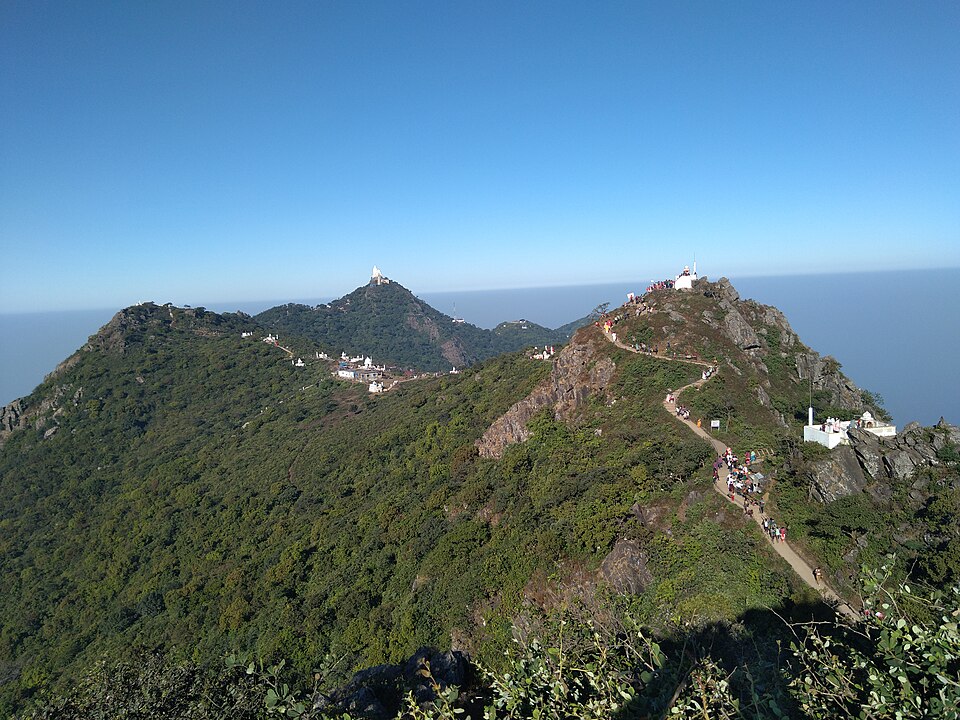
Parasnath Hill

Jharkhand's highest peak and a major Jain pilgrimage, Shikharji, where 20 tirthankaras attained moksha.

Best time: October to MarchBase: Madhuban1 daySpiritualMountains
Directions
From Wikipedia

Parasnath Hill is a mountain peak in the Parasnath hill range. It is located towards the eastern end of the Chota Nagpur Plateau in the Giridih district of the Indian state of Jharkhand. The hill is named after Parshvanatha, the 23rd Jain Tirthankara, who attained liberation here in 8th century BCE. In this connection, there is the holiest Jain pilgrimage, Shikharji on the top of hill. The hill is also known as Sammet Shikhar by other autochthonous of the region in religious contexts.

Read more on Wikipedia ↗
NetarhatHidden gemPhoto: Flashthomsom, CC0

Netarhat

A pine-covered plateau town known as the Queen of Chotanagpur for its sunrises and sunsets.

Best time: October to MarchBase: Ranchi2 daysNatureMountains
Directions
From Wikipedia

Netarhat is a hill station in Latehar district in the Indian state of Jharkhand. The hill station is among the highest points of the Chotanagpur plateau. It is known for the natural beauty of hills, forest and waterfalls. It is also referred to as the "Queen of Chotanagpur".

Read more on Wikipedia ↗

Video by Rakesh Frames on YouTube

Betla National ParkHidden gemPhoto: Marian kispotta, CC BY-SA 4.0

Betla National Park

Part of the Palamau Tiger Reserve, with elephants, bison and two old forts inside the forest.

Best time: November to MayBase: Daltonganj2 daysWildlifeHeritage
Directions
From Wikipedia

Betla National Park is a national park located in the Latehar and Palamu district of Jharkhand, India. Its the only national park in the state. It is spread over an area of 226.32 km2 and is a part of the Palamu Tiger Reserve. It was declared a national park in 1986. The park hosts a wide variety of wildlife.

Read more on Wikipedia ↗

Video by Soumya's Travel Logs on YouTube

Dalma Wildlife SanctuaryHidden gemPhoto: Joydeep 87, CC BY-SA 4.0

Dalma Wildlife Sanctuary

Forested hills above Jamshedpur known for wild elephants and sunrise views.

Best time: November to MayBase: Jamshedpur1 dayWildlifeNature
Directions
From Wikipedia

Dalma Wildlife Sanctuary is a wildlife sanctuary in the Indian state of Jharkhand. It was inaugurated in 1975 and provides habitat for an Indian elephant population.

Read more on Wikipedia ↗
Patratu ValleyHidden gemPhoto: Jharkhand Tourism Department, CC0

Patratu Valley

A hairpin-bend ghat road above a big reservoir, the most photographed drive in Jharkhand.

Best time: July to FebruaryBase: Ranchi1 dayNature
Directions
From Wikipedia

Patratu is a census town in the Patratu in the Ramgarh subdivision of the Ramgarh district in the Indian state of Jharkhand.

Read more on Wikipedia ↗

Food to try

Dhuska, litti, rugra mushroom curry, pitha, handia rice beer

Where to stay

Ranchi as the base, Netarhat forest rest houses, Deoghar for pilgrims

Getting around

Trains to Ranchi, Jamshedpur and Deoghar; hire a car for waterfalls

Good to know

Waterfalls are best from July to October. Start early for Netarhat sunrise point.

History of Jharkhand

Jharkhand sits on the Chota Nagpur Plateau, a land of forests, rivers and rich mineral deposits whose name is usually understood to mean land of forests. People have lived here since the Stone Age, and stone tools have been found at many sites across the plateau. Rock shelters such as Isko in Hazaribagh district carry ancient paintings of animals and geometric designs. For thousands of years the region has been home to Adivasi communities, including the Munda, Oraon, Santhal and Ho, whose languages, village councils and festivals remain central to the identity of the state. The Asur community is associated with a very old tradition of smelting iron in small clay furnaces.

In ancient times the forested plateau lay on the edge of the great kingdoms of the Gangetic plain, such as Magadha and the Mauryan Empire, but its hills and jungles allowed local societies to keep much of their independence. During the medieval period the Nagvanshi dynasty ruled large parts of Chota Nagpur for many centuries, moving its capital several times. The ruins of their palace at Navratangarh near Gumla, built around the 17th century, can still be explored. In the Palamu region the Chero rulers built strong hill forts, and the old and new Palamu forts near Betla National Park are popular with visitors today. Mughal armies also campaigned in the region, though control from Delhi was often loose.

After the East India Company gained the right to collect revenue in Bengal, Bihar and Orissa in 1765, British rule spread into the plateau. New landlords, moneylenders and forest laws threatened the land and customs of tribal communities, and the region became known for powerful resistance movements. Tilka Manjhi rose against the Company in the 1780s, the Kol uprising broke out in 1831 to 1832, and in 1855 the brothers Sidhu and Kanhu Murmu led the Santhal Hul, one of the largest tribal rebellions of the century. In the 1890s Birsa Munda led the Ulgulan, or great tumult, and he died in Ranchi jail in 1900. He is still revered across the state.

The colonial period also brought industry. Coal mining grew rapidly around Jharia and Dhanbad, and in the early 20th century the Tata iron and steel works was established at Sakchi, the town that grew into Jamshedpur. People from Jharkhand took part in the revolt of 1857 and in the national freedom movement, and in 1940 the Indian National Congress held its annual session at Ramgarh.

After independence in 1947 the region formed the southern part of the state of Bihar. Demands for a separate state with its own identity had begun even earlier, and the Jharkhand Party led by Jaipal Singh Munda, the former Olympic hockey captain, gave the movement a political voice from around 1950. After decades of campaigning, Jharkhand was carved out of Bihar and became a separate state on 15 November 2000, the birth anniversary of Birsa Munda. Ranchi was chosen as its capital.

Travellers can trace this story at the Palamu forts, the Navratangarh ruins, the terracotta temples of Maluti and the Baidyanath temple at Deoghar. In Ranchi, the old jail where Birsa Munda died is now a memorial park and museum.

Jharkhand: quick answers

What is the best time to visit Jharkhand?

October to March (waterfalls peak July to October)

How do I reach Jharkhand?

Fly or take a train to Ranchi. Most sights are a 1 to 4 hour drive away.

How many days do I need for Jharkhand?

Plan 4 to 6 days to see the highlights, such as Hundru Falls, Baidyanath Dham, Deoghar, Ranchi.

What food should I try in Jharkhand?

Dhuska, litti, rugra mushroom curry, pitha, handia rice beer

Where should I stay in Jharkhand?

Ranchi as the base, Netarhat forest rest houses, Deoghar for pilgrims

Neighbouring states

Timings, fees, permits and road conditions change. Please check official sources before you travel.